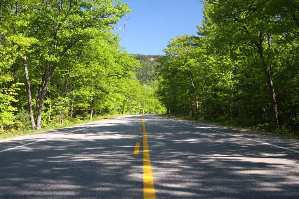
One of New Hampshire’s top fall destinations is The Kancamagus Scenic Highway. The name of this road is mouth full, but it totally lives up to its beautiful name. Hundreds of thousands of visitors flock the White Mountain highway each year to drive the 34 mile road which begins at the intersection of Route 16 in Conway and heads through the White Mountain National Forest ending in Lincoln near Interstate 93.
The Swift River allows visitors the opportunity to view nature as it is intended to be, with amazing scenic overlooks, walking and hiking trails, swimming holes, waterfalls and historic landmarks.
History Of The Kancamagus Highway
The Kancamagus Highway was constructed in 1959 by the NH Dept. of Public Works & Highways, The US bureau of public Roads, and the US Forest Service. The National Forest set aside the land and placed it in conservation in 1911 but the road wasn’t complete until 1959. The road was paved in 1964 and was plowed for the first time, allowing winter traffic in 1968.The name Kancamagus came from an Indian named Kancamagus which means the fearless one.
Before Embarking On The Kancamagus Highway
Before you decide to take a trip down the Kancamagus Highway there are a few things you will want to keep in mind. To park along the highway you will need to have a pass. You can purchase a parking pass at the Ranger Station, daily for $5.00. A parking pass is needed to park at any of the designated parking areas along the way or for any of the hiking trail head parking lots.
You will want to take note that there are no gas stations, stores, or restaurants along the Kancamagus, so make sure that you gas up before hitting the highway. Also there is no cell phone service on this 34 mile trip.
The time of year you decided to visit the Kancamagus Highway will also make a difference in your trip planning. The Spring, Summer, and Fall can be heavily traveled with up to 4,000 visitors a day during peak foliage. Knowing the amount of possible traffic will help you to decide how long you will be gone for. The Kanc is open during the winter time months which can be just as beautiful as the other seasons but you will want to be prepared for snow squalls and unpredictable weather. Once in a while if a storm takes place with a lot of snow they will temporarily shut down the highway to clear the snow.
One more thing to note is that there is no camping or fires within a ¼ mile from the highway. There are 6 campgrounds on the Kancamagus Highway that you can camp in if you decide to make your trip longer than a day. For information about the campground you can contact any of these listed. The Covered Bridge Campground, Blackberry Crossing Campground, Jigger Johnson Campground, Passaconaway Campground, Big Rock Campground, and Hancock Campground.
A Tour Of The Kancamagus Highway
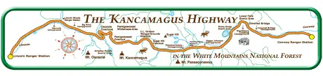
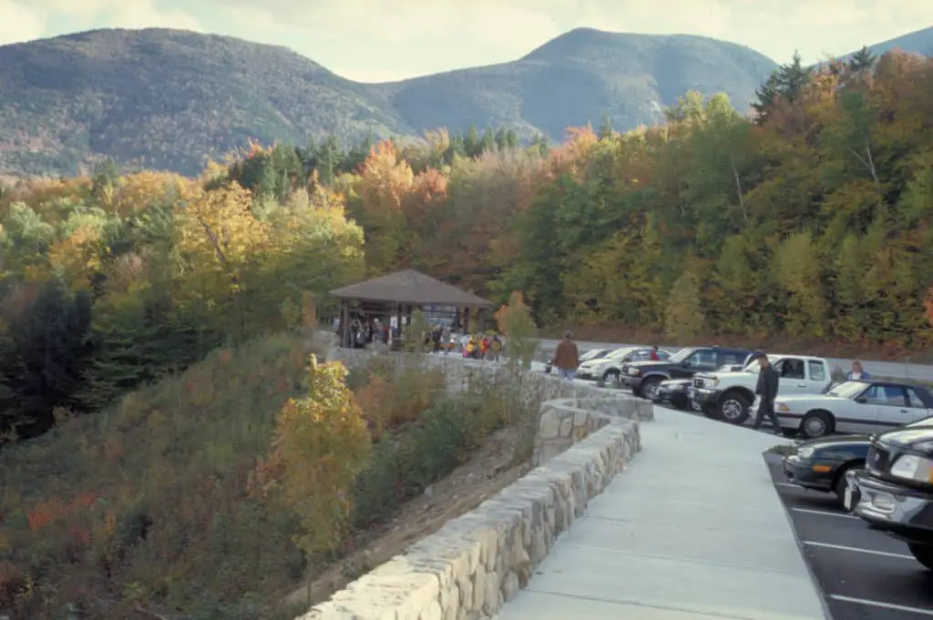
The Kancamagus is one of the easiest road trips you will take as there is only one main road to follow and there are so many different spots that you can stop at along the 34 miles that you can make this trip in one day or spend a whole week exploring the area. You will want to start your tour on the Conway side by route 16 where the Ranger Station is located. Here is a list of some of the stops along the way. The mileage listed is from the Ranger Station.
Ranger Station – 0 Mile Mark
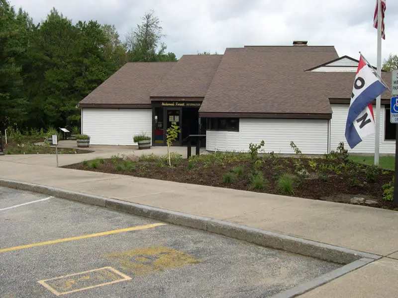
The Ranger Station is the visitors building where you can go in, use the bathroom, fill your water bottle, purchase your parking pass, ask any questions, and grab a map of all the stops on the Kancamagus Highway.
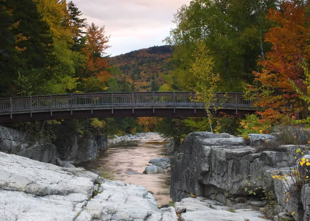
Albany Covered Bridge And Boulder Loop Trail – 6.0 Mile Mark
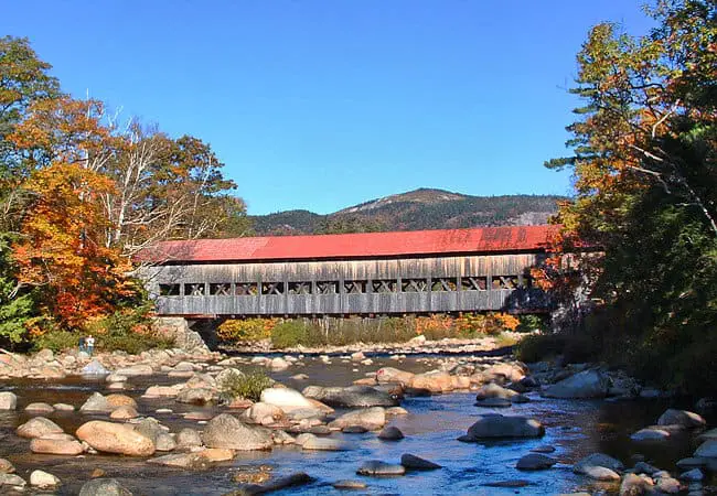
The amazing Albany Covered Bridge (see also ‘Covered Bridges In New Hampshire‘) sits above the boulder studded Swift River and was originally built in 1858. The bridge was resorted in 1970 and has a parking area located just outside the entrance to the bridge. Take a walk over this amazing bridge and enjoy all of its contractual beauty. On the other side of the bridge you can use the picnic tables and there is a fishing area.
Across the street from the parking area is the trailhead for Boulder Loop Trail. The trail is considered moderately easy and is a 2.8 mile round trip hike offering views of the Swift River and a view of Mount Chocorua located just to the south
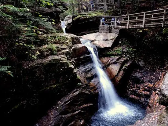
Swift River Lower Falls – 7.0 Mile Mark
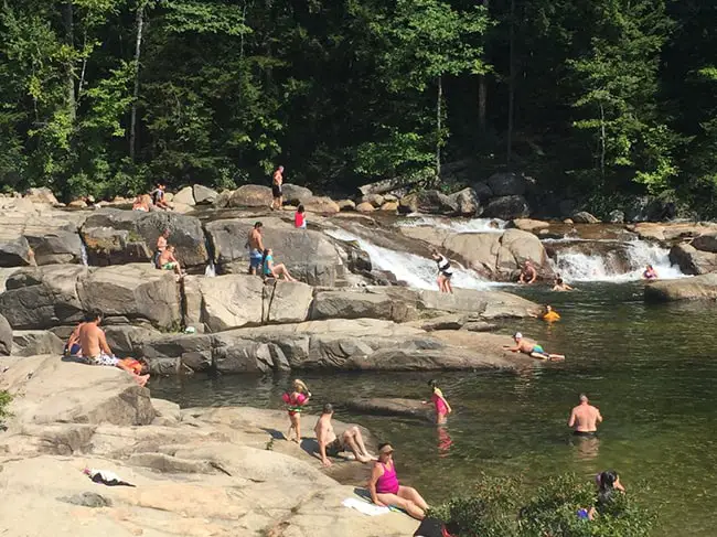
The Swift River Lower Falls is a very popular swimming spot. My family has been here many times and it always has people there enjoying the rocks, wading in the river, swimming in the larger pools and even using the natural water slides to move from pool to pool. The water is always cool even in the summer but there is nothing more refreshing than crystal clear river water on a hot humid day. The parking area has bathrooms and changing rooms but does fill up fast especially in the summer months.
Rocky Gorge And Falls Pond Trail – 9.2 Mile Mark
Rocky Gorge has a small path that brings you to the gorge viewing and a bridge which crosses the river. If you look upstream you can view a waterfall that is part of the amazing gorge. There are lots of rocks on the side of the gorge that are great for having snacks or a picnic lunch. There is no swimming allowed in the gorge area due to the dangerous rocks.
Across the bridge you will find the Lovequist Loop Trail, a path that leads to Falls Pond. This is an easy walk from the bridge and lots of fun for kids too. The pond allows views of wildlife that is native to the white mountains.
Champney Falls And Mount Chocorua Piper Trail – 10.7 Mile Marker
This parking spot is for the Champney Falls Trail Head & The Piper Trail. The Champney Falls trail brings you to a fantastic cascading 70 foot waterfall. When there are periods of high water the falls are amazing. The trail is named after Benjamin Champney, a White Mountain artist who lived from 1817-1907. The Champney Falls loop is a 1.4 mile loop up to the falls and back.
The Piper Trail is a 3.2 mile trail that leads back to Route 16 on the south side of Mount Chocorua.
Russell – Colbath Historic Homestead Site – 12.7 Mile Mark
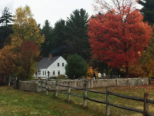
The Russell-Colbath House is a 19th century farmhouse that operates as a historic house museum. If you are able to visit this house you will get to learn about the history of the Passaconaway Valley and the families that lived in the house. They have an on-site historic interpreter and artifacts that have been uncovered right around the house. The Russell-Colbath Homestead is listed on the National Register of Historic Places and is open from July through September.
The home was built by a sawmill operator Tomas Russell in 1832. The house was turned over to his granddaughter Ruth Priscilla and her husband, Thomas Alden Colbath in 1887. One day in 1891 Thomas left the house letting Ruth know that he would return in a little while. He didn’t return that night and so Ruth hung a lantern out for him. She hung that lanter for the next 39 years and he never returned. However after Ruth’s death Thomas showed up at the home looking to claim the house as his own. He was denied and went about his rambling ways.
Mount Hedgehog – 14 Mile Mark
The Mount Hedgehog trail is accessed at the beginning of the University Of NH Downes Brook Trailhead parking. This is across from The Passaconaway Campground. The hike is a moderately difficult loop trail that climbs to the top of the 2,500 foot mountain and has views of the surrounding mountains and Swift River.
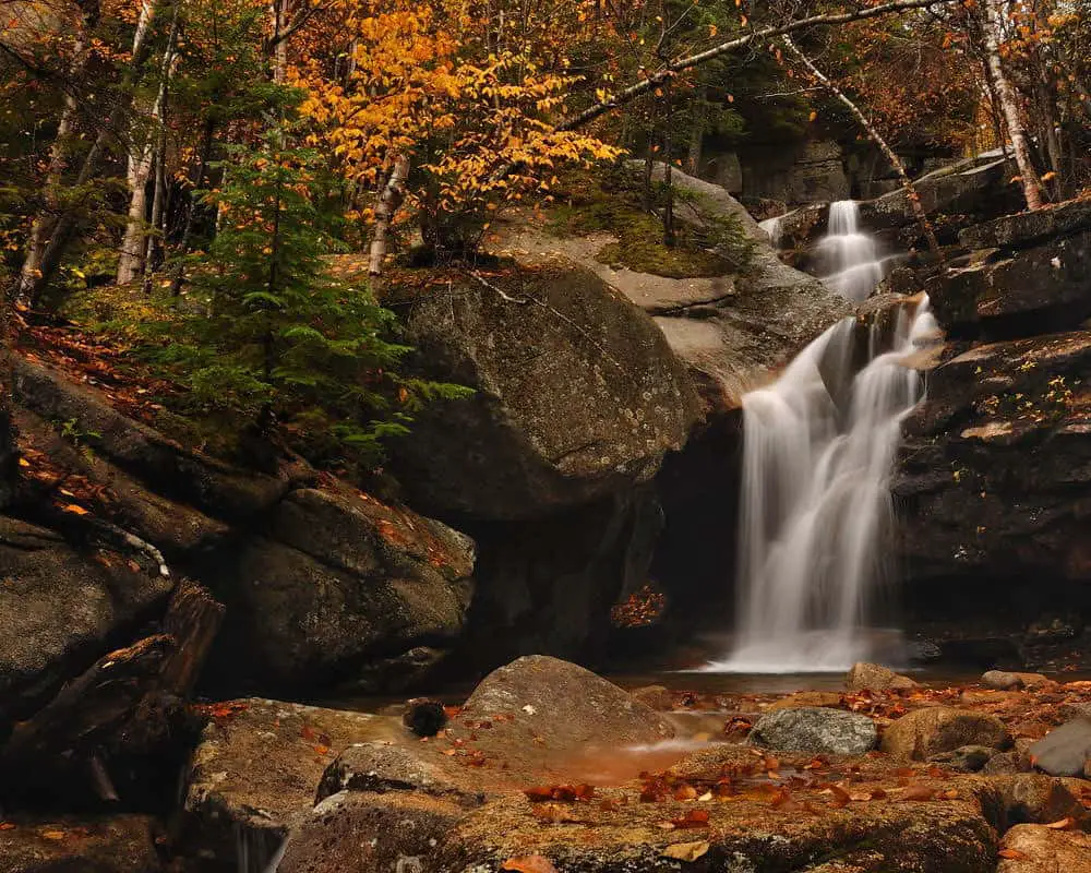
Sabbaday Falls – 15.6 Mile Mark
Sabbaday Falls is also another favorite of my family. This easy 4/10 of a mile walk brings you to the falls area which is a series of falls that flow through the flume like rock formations that were created during the last ice age. The parking lot has a picnic area and bathrooms available.
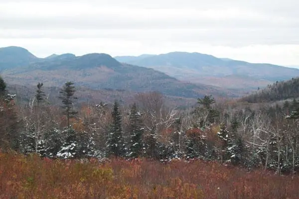
Sugar Hill Scenic Overlook – 17.6 Mile Mark
Sugar Hill Scenic Overlook is about 17 miles down the Kancamagus Highway and has fantastic views of Sugar Hill, Mt. Tremont, Owl Cliff, Bear Mountain, and the Swift River Valley. You will definitely want to pull over and take advantage of the picture worth views.
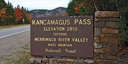
CL Graham/Wangan Grounds Scenic Overlook – 21.9 Mile Mark
The CL Graham/Wangan Grounds Scenic Overlook is the overlook that sits at the highest point of elevation on the Kancamagus Highway and is near the top of Mount Kancamagus. The 2,855 feet of elevation allows for the most spectacular views. The top of Mount Kancamagus is where both the Swift River and the Pemigewasset River which both eventually feed into the Atlantic Ocean.
Greely Ponds Trail – 24 Mile Mark
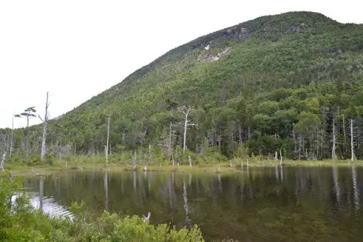
The Greely Ponds Trail is an easy 5 mile round trip trail that will take you about 3 hours to complete. About a mile from the start of the trail is a pull off with views of the two beautiful ponds. Upper Greely pond is a deeper pond that is surrounded by old growing timber and mountain cliffs. The Lower Pond is more like your typical beaver pond. Both of these ponds allow fishing if you have a license. This trail is definitely worth the walk with all of the scenic views and wildlife.
Loon Mountain Ski Area – 29 Mile Mark
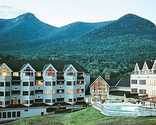
Loon Mountain Ski Area Resort is located in Lincoln NH and is at the western end of the Kancamagus Highway. With Loon Mountain only being 3 miles from Interstate 93 this is basically the end of the Kanc. Loon Mountain is a resort that offers not only winter activities but things year round.
Enjoying The Kancamagus Highway
Your trip down the Kancamagus will be memorable any way you decided to take it, but if you have the time you should make a plan to stop at each destination on the map. Our family has done this trip a few times as we really wanted to be able to walk and hike each of the paths and trails they have. It is also a great trip to take at each of the seasons as the views change with the season. The Kancamagus Highway is a destination must stop for all New Hampshirites and anyone visiting New Hampshire.
PS – Be sure to check out our NH campground guide if you’re looking for great spot to camp!